The Multiscale All-Sky Reference Survey (MARS)
The Next Generation of Gradient Correction and Mosaic Construction Tools
Current gradient correction and mosaic generation techniques have severe limitations. In the case of gradient correction, traditional methods such as our DynamicBackgroundExtraction tool (DBE), as well as existing third-party copies, are based on samples located over supposedly 'free' sky background regions to generate an interpolated model of the gradients in the image. Despite the advanced statistical data analysis algorithms implemented in these tools, this is a highly inaccurate and inefficient way to model gradients. Firstly, most reasonably deep astronomical images exclude free sky background areas. Secondly, even with the availability of free sky data, we cannot model gradients over regions occupied by any objects of interest using these techniques.
For mosaic construction, current techniques are based on normalization functions calculated exclusively on overlapping mosaic areas, where an initial frame acts as the reference to build the entire mosaic. A mosaic cannot be constructed reliably using these methods because each newly added tile must be adapted to the existing partial mosaic, which has its own gradients. On the other hand, this assembly technique cannot reconstruct the object structures globally in the mosaic since we are adapting the mosaic tile by tile, not as a whole.
The multiscale gradient correction algorithm, created by PTeam member Vicent Peris in 2020, is an elegant and efficient solution to overcome all of these limitations based exclusively on observational data. With multiscale gradient correction and its generalized variants, we can design and implement a new generation of gradient modeling, mosaic construction, and image normalization tools that will render existing techniques and applications obsolete. You will no longer have to rely on guessed background samples located at subjectively chosen locations or allow a supposedly 'intelligent' system to produce a whole new image for you without your control. We'll give you tools and techniques to model gradients and build mosaics based on true, accurate observational data, preserving the authenticity of your images and maximizing their documentary value to the greatest technically possible extent.

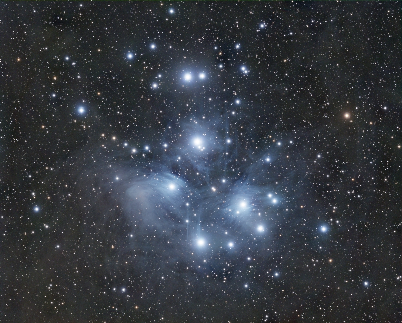
Image of Messier 45 (Pleiades) before and after multiscale gradient correction. Image courtesy of Edoardo Luca Radice (PTeam).
The MARS Project
For the next generation of tools described above to become reality, we need observational data. We already have the best possible source for modeling multiplicative gradients available on the PixInsight platform: the Gaia star catalog. With our advanced spline-based astrometric solutions, hybrid PSF/aperture photometry, and Gaia astrometric and spectrophotometric data available as efficient local databases in our native XPSD (eXtensible Point-Source Database) format, accurate modeling and correction of multiplicative gradients is a reality on the current PixInsight/PCL development platform. Our SpectrophotometricColorCalibration tool is an excellent example of the successful application of Gaia spectrophotometric data for a similar task.
For modeling additive gradients, we have the necessary algorithms designed and ready to be implemented, but we still lack the required observational data. Unfortunately, no reliable and sufficiently extensive source exists to answer a straightforward question: what is the globally normalized brightness measurable at an arbitrary location on the celestial sphere? To answer this question, which is a necessary precondition to implement the multiscale gradient correction algorithm in a generalizable fashion, we need to acquire an accurately normalized, deep image of the entire celestial sphere at several spatial resolutions, at several wavelengths adapted to most practical imaging scenarios. This necessity leads to the Multiscale All-Sky Reference Survey (MARS).
We are currently investing a significant amount of economic, technical, and human resources in acquiring MARS data with two dedicated, robotic observation stations installed at the AstroCamp Observatory in Southern Spain and a high-performance server dedicated to the automated MARS data processing pipeline. With these facilities, we hope to complete the acquisition of the first two layers of MARS data for the Northern Hemisphere with focal lengths of 35 and 135 mm in about 1.5 years.
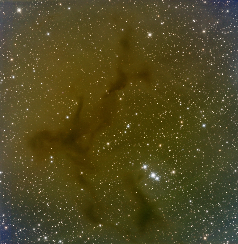

Image of the Barnard 150 region before and after multiscale gradient correction.
User-Contributed MARS Data
Despite our efforts to acquire MARS data as quickly as possible with our resources, we need the collaboration of PixInsight users to release the first version of this project with the necessary levels of quality and completeness. PixInsight has a large user community spanning more than 95 countries, with a vast potential to acquire the data required to complete an all-sky MARS survey with optimal signal-to-noise ratio levels.
We need accurately calibrated, wide-field master light frames acquired from dark skies (ideally, Bortle scale ≤ 3). If you are a licensed PixInsight user and want to contribute to the future of astronomical image processing with us, please consider uploading your images to our corporate servers:
We highly appreciate your contributions. Thank you so much for your support!
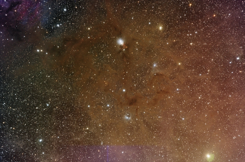
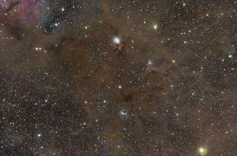
Image of the NGC 1333 region before and after multiscale gradient correction.
Summary of MARS Resources
- Technical description of the Multiscale Gradient Correction algorithm, by Vicent Peris (2020).
- Technical description of the Multiscale All-Sky Reference Survey (MARS), by Vicent Peris et al. (2023)
- Dedicated PixInsight Forum section for discussion on MARS project topics.
- MARS Data Upload System.
- Main MARS project page (this page).

A MARS test mosaic generated with data acquired during November 2023 for proof-of-concept purposes.