arrowspace90
Active member
I did a dumb thing about a week ago. I ran out of space on my SSD hard drive, so I unplugged it and used a new drive. Well, the Gaia catalog was on the old drive. When I realized that, duh, no wonder PCC wouldn't work. So, I plugged that drive back in and was confident that would fix the problem. It didn't. I tried switching to the online catalogs. Failed repeatedly. I tried switching off from the FITS image coordinates to the look up coordinates (they differed). Failed repeatedly.
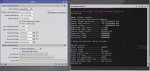
So yesterday I deleted the old catalog and redownloaded it on the newer drive. It fails every time, even though I see that the new data is being used in PixInsight. I see it being referenced on the process console.
It takes forever for my fast computer to go up to "try #32" before reporting "failure to plate solve".
It says this usually happens when the coordinates are too far from the meta data. Ok, well I tried the official look up coordinates.
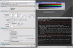
I made a copy of the image to put on a FB forum and the 1 guy that tried my image WAS ABLE to run PCC on it the first time! He didn't even change it from "standard spiral galaxy" and it worked. He sent me a screen shot of the PCC process and I carefully typed in exactly what worked for him. It failed. I will copy the image here.
This tells me the problem is on my end. What can prevent PCC from plate solving on my computer? I rebooted the first thing. I am not an IT guy, but I am dead in the water until I can figure this glitch out. Do you have ANY troubleshooting suggestions, because I am out of ideas.
 drive.google.com
I forgot to say, my scope is RASA 8, with FL 400. Camera is ASI2600MC, pixel size 3.76. I realize that having these wrong will prevent plate solving and that this is typically the reason PCC fails, right?
Thank you.
So yesterday I deleted the old catalog and redownloaded it on the newer drive. It fails every time, even though I see that the new data is being used in PixInsight. I see it being referenced on the process console.
It takes forever for my fast computer to go up to "try #32" before reporting "failure to plate solve".
It says this usually happens when the coordinates are too far from the meta data. Ok, well I tried the official look up coordinates.
I made a copy of the image to put on a FB forum and the 1 guy that tried my image WAS ABLE to run PCC on it the first time! He didn't even change it from "standard spiral galaxy" and it worked. He sent me a screen shot of the PCC process and I carefully typed in exactly what worked for him. It failed. I will copy the image here.
This tells me the problem is on my end. What can prevent PCC from plate solving on my computer? I rebooted the first thing. I am not an IT guy, but I am dead in the water until I can figure this glitch out. Do you have ANY troubleshooting suggestions, because I am out of ideas.
STARS_DBE.xisf
drive.google.com
I forgot to say, my scope is RASA 8, with FL 400. Camera is ASI2600MC, pixel size 3.76. I realize that having these wrong will prevent plate solving and that this is typically the reason PCC fails, right?
Thank you.
Last edited: